Hiking Mount Elbert via the Northeast Ridge: Colorado’s Tallest Peak
Ready to conquer Colorado’s tallest peak? Join me as I tackle Mount Elbert via the popular Northeast Ridge route — a challenging but rewarding hike with breathtaking panoramic views. In this guide, I share essential facts about the mountain, the legendary rivalry with Mount Massive, and everything you need to know before hitting the trail. From parking tips and gear recommendations to altitude safety advice, this blog has you covered for a successful summit experience. Whether you’re an experienced hiker or a motivated beginner, discover why Mount Elbert is a must-do adventure in the Rockies!
14ERSHIKING
DEVIN
6/29/20253 min read
Mountain Facts
DOWNLOAD A QUICK TRAIL GUIDE HERE
CLASS 1 ROUTE
Elevation: 14,438 feet (4,401 meters) — the highest point in Colorado and the Rocky Mountains
Location: Sawatch Range, Colorado
Prominence: 9,093 feet — one of the most prominent peaks in the U.S.
Trail Type: Out-and-back via the Northeast Ridge
Distance: Approximately 9–10 miles round trip
Elevation Gain: Around 4,400 feet
Difficulty: Moderate to challenging due to steady ascent and high elevation
The Great Colorado Summit Rivalry: Mount Elbert vs. Mount Massive
Mount Elbert’s close neighbor, Mount Massive, sparked a friendly but long-standing debate over which peak is Colorado’s tallest. Mount Massive stands at 14,428 feet — just 12 feet shorter than Elbert’s 14,440 feet. After several surveys, Mount Elbert holds the official title of Colorado’s highest summit, but both remain legendary climbs in the Rockies.
The Northeast Ridge Route
The Northeast Ridge route is one of the most popular and accessible ways to summit Mount Elbert. It starts at the Elbert Creek Trailhead, located off Colorado Highway 91, about 6 miles south of Leadville.
Parking & Trailhead
Parking is available at the Elbert Creek Trailhead, which can fill up on busy weekends—arrive early to secure a spot.
The trailhead sits at approximately 10,400 feet elevation.
Trail Overview
The hike begins below tree line and quickly connects with the Continental Divide Trail (CDT) for a short distance. After leaving the CDT, the trail steadily climbs onto the northeast ridge.
About 2.5 miles in, the forest thins and you break above tree line. This is where the climb gets more exposed and most hikers, including myself, start to slow down. This section gives your first view of the initial false summit.
Following several switchbacks, the trail reaches the first false summit, revealing the second false summit ahead. From here, the climb becomes a steady, grinding ascent to the second false summit. When you reach it, the true summit finally comes into sight — though it may be hard to believe there’s still some distance left.
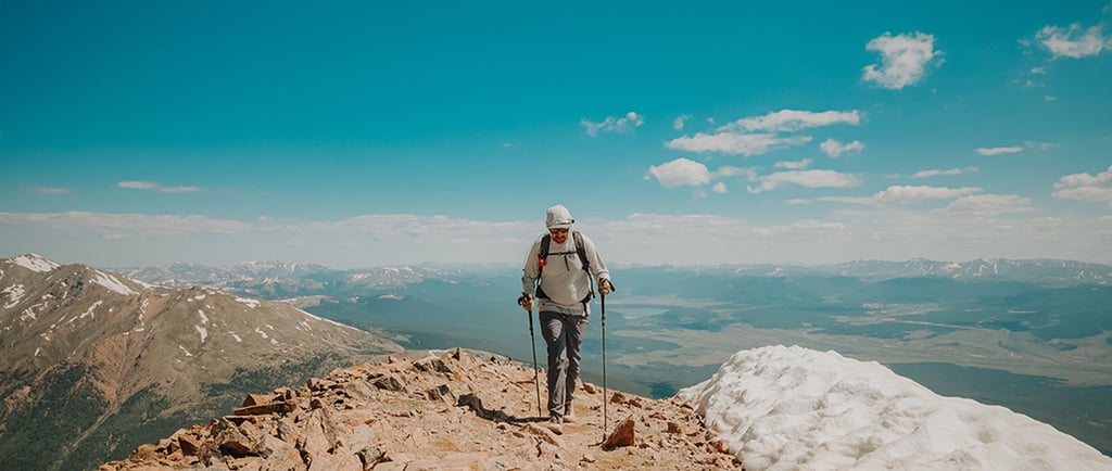
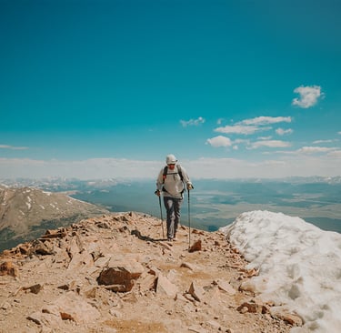
The final push rewards you with breathtaking panoramic views, especially to the west and south. Standing at 14,440 feet, you’ll be on the highest point in Colorado — a moment to savor.
Best Seasons to Hike
Summer and Early Fall (July to September) offer the best conditions, with snow mostly melted and mild weather.
Avoid late spring or early summer due to lingering snowfields, and watch for afternoon thunderstorms common in the summer months.
Fall colors can be spectacular, but temperatures drop quickly, especially above tree line.
Recommended Gear
Footwear: Sturdy hiking boots with good traction.
Clothing: Layered clothing for temperature changes, including a waterproof/windproof jacket.
Hydration: At least 2-3 liters of water; altitude increases dehydration risk.
Sun Protection: Sunglasses, sunscreen, and a hat — UV exposure is stronger at altitude.
Navigation: Map, GPS, or a reliable trail app, especially if weather reduces visibility.
Trekking Poles: Helpful for the steady elevation gain and switchbacks.
Snacks: High-energy, easily digestible foods to fuel your climb.
Emergency Kit: Basic first aid supplies, whistle, and a headlamp in case your hike takes longer than planned.
Safety Tips and Acute Mountain Sickness (AMS)
Climbing Mount Elbert involves significant elevation gain, so it’s important to be aware of altitude-related risks.
Acute Mountain Sickness Symptoms
Headache
Nausea or vomiting
Dizziness or lightheadedness
Fatigue or weakness
Shortness of breath
Difficulty sleeping
If you or anyone in your group experiences these symptoms, it’s critical to:
Stop ascending immediately
Rest and hydrate
Descend to lower elevation if symptoms worsen or don’t improve
Additional Safety Tips
Start early to avoid afternoon thunderstorms common in the Rockies.
Check weather forecasts before your hike and be prepared to turn back if conditions deteriorate.
Pace yourself to avoid overexertion, especially above 12,000 feet.
Let someone know your plans and expected return time.
Be mindful of wildlife and keep a respectful distance.
Carry a fully charged phone or communication device, but don’t rely solely on cell service—it may be limited.
Mount Elbert’s Northeast Ridge offers an unforgettable challenge, stunning views, and the thrill of standing on Colorado’s highest peak. With preparation and respect for the mountain’s demands, it’s an adventure you won’t forget.